
Thank you for supporting this site ❤️
Make a donation
Make a donation
Demer topographic map
Click on the map to display elevation.
Thank you for supporting this site ❤️
Make a donation
Make a donation
About this map
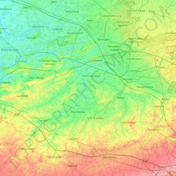
Name: Demer topographic map, elevation, terrain.
Location: Demer, Limburg, Flandern, Belgien (50.79922 4.69261 51.00898 5.52224)
Average elevation: 64 m
Minimum elevation: 3 m
Maximum elevation: 224 m
Thank you for supporting this site ❤️
Make a donation
Make a donation
Other topographic maps
Click on a map to view its topography, its elevation and its terrain.