
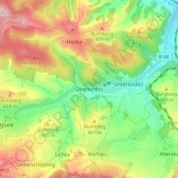
Oberköditz topographic map
Interactive map
Click on the map to display elevation.
About this map
Name: Oberköditz topographic map, elevation, terrain.
Average elevation: 380 m
Minimum elevation: 283 m
Maximum elevation: 501 m
Other topographic maps
Click on a map to view its topography, its elevation and its terrain.
Lichta
Deutschland > Thüringen > Landkreis Saalfeld-Rudolstadt > Königsee
Lichta, Königsee, Landkreis Saalfeld-Rudolstadt, Thüringen, 07426, Deutschland
Average elevation: 425 m
Horba
Deutschland > Thüringen > Landkreis Saalfeld-Rudolstadt > Königsee
Horba, Königsee, Landkreis Saalfeld-Rudolstadt, Thüringen, 07426, Deutschland
Average elevation: 382 m
Königsee
Deutschland > Thüringen > Landkreis Saalfeld-Rudolstadt > Königsee
Königsee, Landkreis Saalfeld-Rudolstadt, Thüringen, 07426, Deutschland
Average elevation: 461 m
Paulinzella
Deutschland > Thüringen > Landkreis Saalfeld-Rudolstadt > Königsee > Paulinzella
Paulinzella, Königsee, Landkreis Saalfeld-Rudolstadt, Thüringen, Deutschland
Average elevation: 425 m