
Thank you for supporting this site ❤️
Make a donation
Make a donation
Šiauliai topographic map
Click on the map to display elevation.
Thank you for supporting this site ❤️
Make a donation
Make a donation
Šiauliai
Altitude: Rėkyvos the lake water level – 129.8 m (425.85 ft) above sea level, Talsos lake level – 103.0 m (337.93 ft) in the city center – 128.4 m (421.26 ft), Salduvės Hill – 149.7 m (491.14 ft) above sea level.
Thank you for supporting this site ❤️
Make a donation
Make a donation
About this map
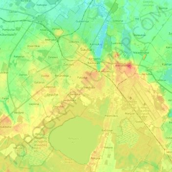
Name: Šiauliai topographic map, elevation, terrain.
Average elevation: 124 m
Minimum elevation: 99 m
Maximum elevation: 153 m
Thank you for supporting this site ❤️
Make a donation
Make a donation