
Thank you for supporting this site ❤️
Make a donation
Make a donation
Bagori topographic map
Click on the map to display elevation.
Thank you for supporting this site ❤️
Make a donation
Make a donation
About this map
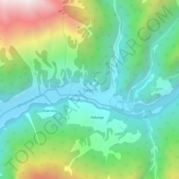
Name: Bagori topographic map, elevation, terrain.
Location: Bagori, Bhatwari, Uttarkashi District, Uttarakhand, India (31.01959 78.72169 31.05959 78.76169)
Average elevation: 2,955 m
Minimum elevation: 2,450 m
Maximum elevation: 4,146 m
Thank you for supporting this site ❤️
Make a donation
Make a donation
Other topographic maps
Click on a map to view its topography, its elevation and its terrain.
Thank you for supporting this site ❤️
Make a donation
Make a donation
Thank you for supporting this site ❤️
Make a donation
Make a donation