
Thank you for supporting this site ❤️
Make a donation
Make a donation
Genting Island topographic map
Click on the map to display elevation.
Thank you for supporting this site ❤️
Make a donation
Make a donation
About this map
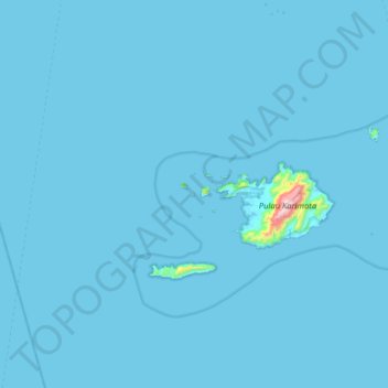
Name: Genting Island topographic map, elevation, terrain.
Average elevation: 8 m
Minimum elevation: -1 m
Maximum elevation: 935 m
Thank you for supporting this site ❤️
Make a donation
Make a donation
Other topographic maps
Click on a map to view its topography, its elevation and its terrain.
Pulau Maya
Indonesia > West Kalimantan > Kayong Utara
Maya Karimata (now just called Maya or Maja) is an island in North Kayong Regency in West Kalimantan Province, Indonesia. Its area is 992.1 square kilometres (383.1 square miles). Maya Island and the Karimata Islands formerly comprised a single administrative district (kecamatan) within the Regency, but it has…
Average elevation: 4 m
Thank you for supporting this site ❤️
Make a donation
Make a donation
Thank you for supporting this site ❤️
Make a donation
Make a donation