
Thank you for supporting this site ❤️
Make a donation
Make a donation
San Clemente topographic map
Click on the map to display elevation.
Thank you for supporting this site ❤️
Make a donation
Make a donation
About this map
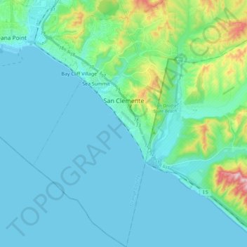
Name: San Clemente topographic map, elevation, terrain.
Location: San Clemente, Orange County, California, United States (33.33367 -117.68169 33.49083 -117.57118)
Average elevation: 60 m
Minimum elevation: -1 m
Maximum elevation: 416 m
Thank you for supporting this site ❤️
Make a donation
Make a donation
Other topographic maps
Click on a map to view its topography, its elevation and its terrain.