
Schonungen topographic map
Interactive map
Click on the map to display elevation.
About this map
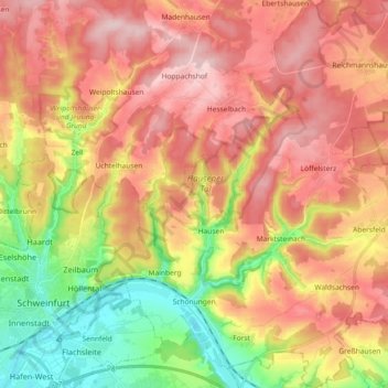
Name: Schonungen topographic map, elevation, terrain.
Location: Schonungen, Landkreis Schweinfurt, Beieren, 97453, Duitsland (50.02425 10.25747 50.14170 10.43334)
Average elevation: 325 m
Minimum elevation: 203 m
Maximum elevation: 424 m
Other topographic maps
Click on a map to view its topography, its elevation and its terrain.
Untereuerheim
Duitsland > Beieren > Landkreis Schweinfurt
Untereuerheim, Grettstadt, Landkreis Schweinfurt, Beieren, 97503, Duitsland
Average elevation: 250 m