
Loiret topographic map
Interactive map
Click on the map to display elevation.
About this map
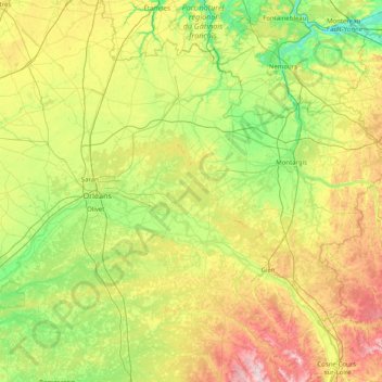
Name: Loiret topographic map, elevation, terrain.
Location: Loiret, Centre-Val de Loire, Metropolitan France, France (47.48306 1.51220 48.34495 3.12864)
Average elevation: 135 m
Minimum elevation: 43 m
Maximum elevation: 361 m
Other topographic maps
Click on a map to view its topography, its elevation and its terrain.
Amboise
France > Centre-Val de Loire > Indre-et-Loire
Amboise, Loches, Indre-et-Loire, Centre-Val de Loire, Metropolitan France, 37400, France
Average elevation: 91 m
Coust
France > Centre-Val de Loire > Cher
Coust, Saint-Amand-Montrond, Cher, Centre-Val de Loire, Metropolitan France, 18210, France
Average elevation: 201 m
Basse-Bretagne
France > Centre-Val de Loire > Indre-et-Loire > Château-la-Vallière
Basse-Bretagne, Château-la-Vallière, Chinon, Indre-et-Loire, Centre-Val de Loire, Metropolitan France, 37330, France
Average elevation: 89 m
La Patte au Loup
France > Centre-Val de Loire > Indre-et-Loire > Chouzé-sur-Loire
La Patte au Loup, Chouzé-sur-Loire, Chinon, Indre-et-Loire, Centre-Val de Loire, Metropolitan France, 37140, France
Average elevation: 31 m
Bourges
France > Centre-Val de Loire > Cher
Bourges, Cher, Centre-Val de Loire, Metropolitan France, 18000, France
Average elevation: 146 m