
Puntarenas Province topographic map
Interactive map
Click on the map to display elevation.
About this map
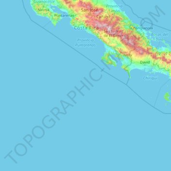
Name: Puntarenas Province topographic map, elevation, terrain.
Location: Puntarenas Province, Costa Rica (5.49916 -87.10200 10.33744 -82.71178)
Average elevation: 118 m
Minimum elevation: 0 m
Maximum elevation: 3,724 m
Other topographic maps
Click on a map to view its topography, its elevation and its terrain.
Valle Azul
Costa Rica > Alajuela Province > Cantón de San Ramón > San Lorenzo
Average elevation: 226 m
La Catarata
Costa Rica > Alajuela Province > Cantón de San Carlos > La Fortuna
Average elevation: 398 m