
Thank you for supporting this site ❤️
Make a donation
Make a donation
Nusa Dua topographic map
Click on the map to display elevation.
Thank you for supporting this site ❤️
Make a donation
Make a donation
About this map
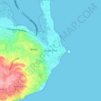
Name: Nusa Dua topographic map, elevation, terrain.
Average elevation: 67 m
Minimum elevation: 0 m
Maximum elevation: 2,969 m
Thank you for supporting this site ❤️
Make a donation
Make a donation
Other topographic maps
Click on a map to view its topography, its elevation and its terrain.
Pecatu
Indonesia > Bali > Kuta Selatan
Pecatu is located in South Kuta District of Badung Regency. It is at the western end of the Bukit Peninsula in south Bali, and has a hilly topography with limestone cliffs isolating small, short beaches that have been privately developed. Nusa Dua, on the opposite side of the peninsula, is flat and is a…
Average elevation: 64 m
Thank you for supporting this site ❤️
Make a donation
Make a donation