
Thank you for supporting this site ❤️
Make a donation
Make a donation
Dalga topographic map
Click on the map to display elevation.
Thank you for supporting this site ❤️
Make a donation
Make a donation
About this map
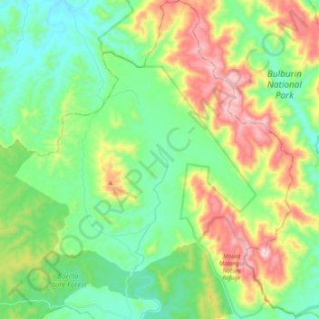
Name: Dalga topographic map, elevation, terrain.
Location: Dalga, Bundaberg Region, Queensland, Australia (-24.70188 151.38294 -24.53600 151.54230)
Average elevation: 321 m
Minimum elevation: 111 m
Maximum elevation: 763 m
Thank you for supporting this site ❤️
Make a donation
Make a donation
Other topographic maps
Click on a map to view its topography, its elevation and its terrain.