
Thank you for supporting this site ❤️
Make a donation
Make a donation
Dean topographic map
Click on the map to display elevation.
Thank you for supporting this site ❤️
Make a donation
Make a donation
About this map
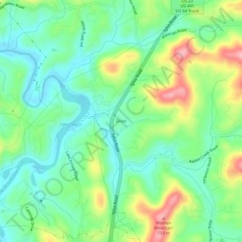
Name: Dean topographic map, elevation, terrain.
Location: Dean, Macon County, North Carolina, 28734, United States (35.19426 -83.37960 35.23426 -83.33960)
Average elevation: 652 m
Minimum elevation: 600 m
Maximum elevation: 755 m
Thank you for supporting this site ❤️
Make a donation
Make a donation
Other topographic maps
Click on a map to view its topography, its elevation and its terrain.
Little Tennessee River
United States > North Carolina > Macon County > Franklin > East Franklin
Average elevation: 641 m