
Thank you for supporting this site ❤️
Make a donation
Make a donation
Kingston topographic map
Click on the map to display elevation.
Thank you for supporting this site ❤️
Make a donation
Make a donation
About this map
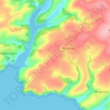
Name: Kingston topographic map, elevation, terrain.
Location: Kingston, South Hams, Devon, England, United Kingdom (50.29449 -3.94948 50.33109 -3.87788)
Average elevation: 63 m
Minimum elevation: -3 m
Maximum elevation: 142 m
Thank you for supporting this site ❤️
Make a donation
Make a donation
Other topographic maps
Click on a map to view its topography, its elevation and its terrain.