
Bashkia Korçë topographic map
Interactive map
Click on the map to display elevation.
About this map
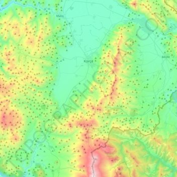
Name: Bashkia Korçë topographic map, elevation, terrain.
Location: Bashkia Korçë, Korçë County, Southern Albania, Albania (40.42333 20.38375 40.69491 20.86238)
Average elevation: 1,154 m
Minimum elevation: 689 m
Maximum elevation: 2,388 m
As of the Köppen climate classification, Korçë falls under the periphery of the warm-summer Mediterranean climate (Csb) zone with an average annual temperature of 10.4 °C (50.7 °F).[73] The warmest month of Korçë is August with an average temperature of 21.3 °C (70.3 °F).[73] By contrast, the coldest month is January with an average temperature of −0.8 °C (30.6 °F).[73] Korçë receives around 766.7 mm (30.19 in) annual precipitation with summer minimum and winter maximum.[73] Temperatures generally remain cooler than western Albania, due to the middle altitude of the plain in which it is situated, but it receives about 2800 hours of solar radiation per year.[73]
Other topographic maps
Click on a map to view its topography, its elevation and its terrain.
Gollomboç
Albania > Southern Albania > Korçë County
Gollomboç, Pustec, Bashkia Pustec, Korçë County, Southern Albania, Albania
Average elevation: 914 m
Pogradec
Albania > Southern Albania > Korçë County > Bashkia Pogradec
Pogradec, Bashkia Pogradec, Korçë County, Southern Albania, 7301, Albania
Average elevation: 762 m
Voskopojë
Albania > Southern Albania > Korçë County
Voskopojë, Bashkia Korçë, Korçë County, Southern Albania, 7029, Albania
Average elevation: 1,270 m
Bashkia Devoll
Albania > Southern Albania > Korçë County
Bashkia Devoll, Korçë County, Southern Albania, Albania
Average elevation: 1,084 m
Zvezdë
Albania > Southern Albania > Korçë County > Bashkia Maliq > Zvezdë
Zvezdë, Bashkia Maliq, Korçë County, Southern Albania, 7014, Albania
Average elevation: 945 m
Korçë
Albania > Southern Albania > Korçë County
Korçë, Bashkia Korçë, Korçë County, Southern Albania, 7001, Albania
Average elevation: 877 m