
The Foss topographic map
Interactive map
Click on the map to display elevation.
About this map
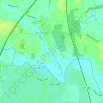
Name: The Foss topographic map, elevation, terrain.
Average elevation: 9 m
Minimum elevation: 3 m
Maximum elevation: 17 m
Other topographic maps
Click on a map to view its topography, its elevation and its terrain.
The Foss
United Kingdom > England > Selby
The Foss, Selby, North Yorkshire, Yorkshire and the Humber, England, LS24 8ED, United Kingdom
Average elevation: 13 m
Adaman Graves
United Kingdom > England > Selby
Adaman Graves, Selby, North Yorkshire, Yorkshire and the Humber, England, LS24 9LY, United Kingdom
Average elevation: 20 m