
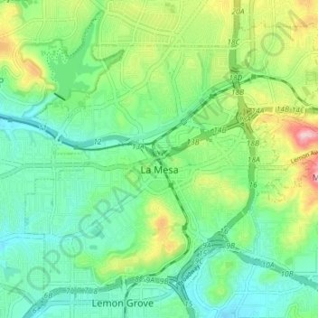
La Mesa topographic map
Interactive map
Click on the map to display elevation.
About this map
Name: La Mesa topographic map, elevation, terrain.
Average elevation: 171 m
Minimum elevation: 104 m
Maximum elevation: 325 m
The climate in the San Diego area, like much of California, often varies significantly over short geographical distances, resulting in micro-climates. In San Diego's case, this is mainly due to the city's topography (the Bay, and the numerous hills, mountains, and canyons). Frequently, particularly during the "May gray/June gloom" period, a thick "marine layer" cloud cover will keep the air cool and damp within a few miles of the coast, but will yield to bright cloudless sunshine approximately 5–10 miles (8–16 km) inland. This happens every year in May and June. Even in the absence of June gloom, inland areas tend to experience higher temperatures than areas closer to the coast.
Other topographic maps
Click on a map to view its topography, its elevation and its terrain.
San Diego
United States > California > San Diego County
San Diego, San Diego County, California, United States
Average elevation: 125 m
San Diego
United States > California > San Diego County > San Diego
San Diego, San Diego County, California, 92101, United States
Average elevation: 57 m