
Etteln topographic map
Interactive map
Click on the map to display elevation.
About this map
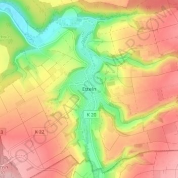
Name: Etteln topographic map, elevation, terrain.
Average elevation: 226 m
Minimum elevation: 141 m
Maximum elevation: 295 m
Other topographic maps
Click on a map to view its topography, its elevation and its terrain.
Elsen
Duitsland > Noordrijn-Westfalen > Kreis Paderborn > Paderborn
Elsen, Paderborn, Kreis Paderborn, Noordrijn-Westfalen, 33106, Duitsland
Average elevation: 113 m
Bad Wünnenberg
Duitsland > Noordrijn-Westfalen > Kreis Paderborn > Bad Wünnenberg > Bad Wünnenberg
Bad Wünnenberg, Kreis Paderborn, Noordrijn-Westfalen, 33181, Duitsland
Average elevation: 351 m
Büren
Duitsland > Noordrijn-Westfalen > Kreis Paderborn > Büren
Büren, Kreis Paderborn, Noordrijn-Westfalen, 33142, Duitsland
Average elevation: 286 m
Salzkotten
Duitsland > Noordrijn-Westfalen > Kreis Paderborn > Salzkotten > Salzkotten
Salzkotten, Kreis Paderborn, Noordrijn-Westfalen, 33154, Duitsland
Average elevation: 127 m
Paderborn
Duitsland > Noordrijn-Westfalen > Kreis Paderborn > Paderborn
Paderborn, Kreis Paderborn, Noordrijn-Westfalen, Duitsland
Average elevation: 155 m