
Hatten topographic map
Interactive map
Click on the map to display elevation.
About this map
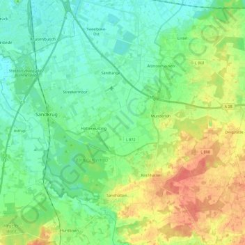
Name: Hatten topographic map, elevation, terrain.
Location: Hatten, Landkreis Oldenburg, Niedersachsen, 26209, Deutschland (52.99196 8.21107 53.10729 8.43366)
Average elevation: 18 m
Minimum elevation: 2 m
Maximum elevation: 46 m
Other topographic maps
Click on a map to view its topography, its elevation and its terrain.
Tungeln
Deutschland > Niedersachsen > Landkreis Oldenburg > Wardenburg
Tungeln, Wardenburg, Landkreis Oldenburg, Niedersachsen, Deutschland
Average elevation: 6 m
Winkelsett
Deutschland > Niedersachsen > Landkreis Oldenburg
Winkelsett, Samtgemeinde Harpstedt, Landkreis Oldenburg, Niedersachsen, Deutschland
Average elevation: 39 m