
Grandval topographic map
Interactive map
Click on the map to display elevation.
About this map
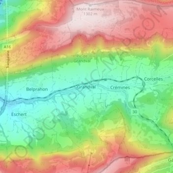
Name: Grandval topographic map, elevation, terrain.
Average elevation: 870 m
Minimum elevation: 532 m
Maximum elevation: 1,299 m
Other topographic maps
Click on a map to view its topography, its elevation and its terrain.
Büx
Schweiz > Bern > Verwaltungskreis Berner Jura > Seehof
Büx, Klein-Probstenberg, Seehof, Verwaltungskreis Berner Jura, Verwaltungsregion Berner Jura, Bern, 2747, Schweiz
Average elevation: 975 m
Schelten
Schweiz > Bern > Verwaltungskreis Berner Jura
Schelten, Verwaltungskreis Berner Jura, Verwaltungsregion Berner Jura, Bern, 2827, Schweiz
Average elevation: 966 m