
Make a donation
Atzendorf topographic map
Click on the map to display elevation.
Make a donation
About this map
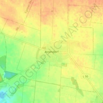
Name: Atzendorf topographic map, elevation, terrain.
Average elevation: 86 m
Minimum elevation: 65 m
Maximum elevation: 98 m
Make a donation
Other topographic maps
Click on a map to view its topography, its elevation and its terrain.
Brumby
Deutschland > Sachsen-Anhalt > Salzlandkreis > Staßfurt
Die Ortslage Brumby liegt 75 Meter über dem Meeresspiegel. Die höchste Erhebung von Brumby ist der Fuchsberg mit knapp 100 Meter. Die Straßen von Brumby sind geprägt von kleinen Höhenunterschieden und verlaufen in der Form eines halben Ringes. Diese Ringe sind durch Querstraßen verbunden. Solche Bauweise…
Average elevation: 76 m
Atzendorf
Deutschland > Sachsen-Anhalt > Salzlandkreis > Staßfurt
Atzendorf liegt im Zentrum Sachsen-Anhalts zwischen dem Südrand der Magdeburger Börde und dem nordöstlichen Rand der Egelner-Staßfurter Mulde, einer stillgelegten Braunkohlenlagerstätte. Der Ort ist von landwirtschaftlichen Flächen umgeben, sein Ortskern liegt auf einer Höhe von 83 Metern. Am südlichen…
Average elevation: 85 m
Make a donation
Hohenerxleben
Deutschland > Sachsen-Anhalt > Salzlandkreis > Staßfurt
Im Norden wird Hohenerxleben vom Saalenebenfluss Bode begrenzt. Östlich schließt sich der bewaldete ehemalige Schlosspark an, während das südliche und westliche Umland von landwirtschaftlichen Nutzflächen geprägt ist. Im Süden sind noch die Restlöcher des früheren Salzabbaus vorhanden. Die bebaute…
Average elevation: 72 m