
Thank you for supporting this site ❤️
Make a donation
Make a donation
Rushville topographic map
Click on the map to display elevation.
Thank you for supporting this site ❤️
Make a donation
Make a donation
About this map
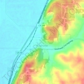
Name: Rushville topographic map, elevation, terrain.
Location: Rushville, Buchanan County, Missouri, United States (39.58532 -95.03115 39.59032 -95.01409)
Average elevation: 271 m
Minimum elevation: 239 m
Maximum elevation: 326 m
Thank you for supporting this site ❤️
Make a donation
Make a donation
Other topographic maps
Click on a map to view its topography, its elevation and its terrain.