
Tongkoko topographic map
Interactive map
Click on the map to display elevation.
About this map
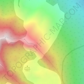
Name: Tongkoko topographic map, elevation, terrain.
Location: Tongkoko, Bitung, Sulawesi du Nord, Indonésie (1.51995 125.19995 1.52005 125.20005)
Average elevation: 614 m
Minimum elevation: 191 m
Maximum elevation: 1,030 m
Other topographic maps
Click on a map to view its topography, its elevation and its terrain.
Bitung
Indonésie > Sulawesi du Nord > Bitung
Bitung, Sulawesi du Nord, 95522, Indonésie
Average elevation: 115 m
Klabat
Indonésie > Sulawesi du Nord > Bitung
Klabat, Bitung, Sulawesi du Nord, Indonésie
Average elevation: 1,106 m