
Dundalk topographic map
Interactive map
Click on the map to display elevation.
About this map
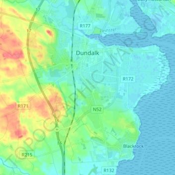
Name: Dundalk topographic map, elevation, terrain.
Location: Dundalk, County Louth, Leinster, Irlande (53.95055 -6.44438 54.02793 -6.34154)
Average elevation: 13 m
Minimum elevation: -1 m
Maximum elevation: 59 m
Other topographic maps
Click on a map to view its topography, its elevation and its terrain.
The Borough District of Drogheda
The Borough District of Drogheda, County Louth, Leinster, Irlande
Average elevation: 50 m
Dundalk
Irlande > County Louth > Dundalk
Dundalk, The Municipal District of Dundalk, County Louth, Leinster, A91 RC44, Irlande
Average elevation: 16 m