
Los Gatos topographic map
Interactive map
Click on the map to display elevation.
About this map
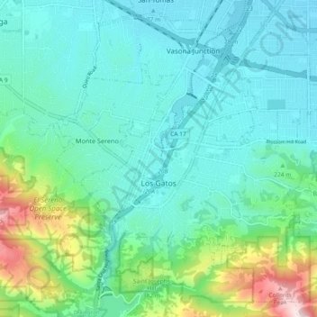
Name: Los Gatos topographic map, elevation, terrain.
Average elevation: 209 m
Minimum elevation: 62 m
Maximum elevation: 786 m
Other topographic maps
Click on a map to view its topography, its elevation and its terrain.
Morgan Hill
Vereinigte Staaten von Amerika > Kalifornien > Santa Clara County
Morgan Hill, Santa Clara County, Kalifornien, 95038, Vereinigte Staaten von Amerika
Average elevation: 153 m
Silicon Valley
Vereinigte Staaten von Amerika > Kalifornien > Santa Clara County > Palo Alto
Silicon Valley, Palo Alto, Santa Clara County, Kalifornien, 94301, Vereinigte Staaten von Amerika
Average elevation: 118 m
Sunnyvale
Vereinigte Staaten von Amerika > Kalifornien > Santa Clara County > Sunnyvale
Sunnyvale, Santa Clara County, Kalifornien, 94807, Vereinigte Staaten von Amerika
Average elevation: 150 m