
Morrocoy topographic map
Interactive map
Click on the map to display elevation.
About this map
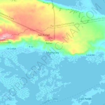
Name: Morrocoy topographic map, elevation, terrain.
Average elevation: 52 m
Minimum elevation: -2 m
Maximum elevation: 241 m
Other topographic maps
Click on a map to view its topography, its elevation and its terrain.
Parque Nacional Morrocoy
Venezuela > Falcón > Morrocoy > Lizardo
Parque Nacional Morrocoy, Lizardo, Parroquia Tucacas, Municipio Silva, Falcón, Región Centroccidental, Venezuela
Average elevation: 10 m
Playa Cayo Sombrero (Este)
Playa Cayo Sombrero (Este), Morrocoy, El Tuque, Morrocoy, Municipio Silva, Falcón, Venezuela
Average elevation: 0 m