
Thank you for supporting this site ❤️
Make a donation
Make a donation
Yerne topographic map
Click on the map to display elevation.
Thank you for supporting this site ❤️
Make a donation
Make a donation
About this map
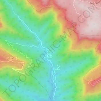
Name: Yerne topographic map, elevation, terrain.
Location: Yerne, Jaoli, Satara, Maharashtra, 412806, India (17.85001 73.68257 17.89001 73.72257)
Average elevation: 947 m
Minimum elevation: 688 m
Maximum elevation: 1,313 m
Thank you for supporting this site ❤️
Make a donation
Make a donation
Other topographic maps
Click on a map to view its topography, its elevation and its terrain.