
Lewisville topographic map
Interactive map
Click on the map to display elevation.
About this map
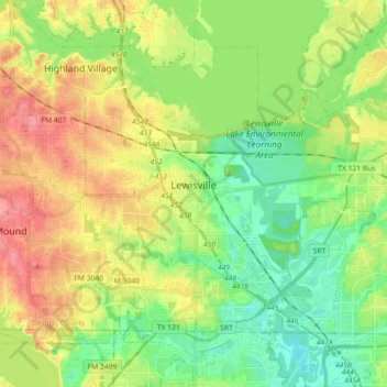
Name: Lewisville topographic map, elevation, terrain.
Location: Lewisville, Denton County, Texas, États-Unis d'Amérique (32.98512 -97.04566 33.10035 -96.86587)
Average elevation: 160 m
Minimum elevation: 129 m
Maximum elevation: 202 m
Other topographic maps
Click on a map to view its topography, its elevation and its terrain.
Lewisville
États-Unis d'Amérique > Texas > Denton County > Lewisville
Lewisville, Denton County, Texas, 75067, États-Unis d'Amérique
Average elevation: 174 m
Aubrey
États-Unis d'Amérique > Texas > Denton County
Aubrey, Denton County, Texas, États-Unis d'Amérique
Average elevation: 197 m