
Uhldingen-Mühlhofen topographic map
Interactive map
Click on the map to display elevation.
About this map
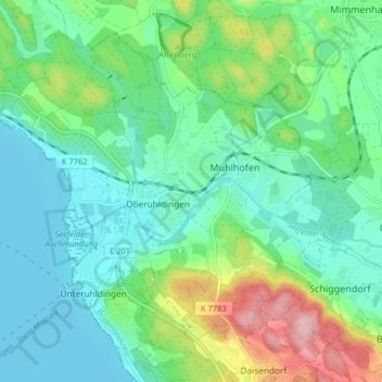
Name: Uhldingen-Mühlhofen topographic map, elevation, terrain.
Average elevation: 440 m
Minimum elevation: 393 m
Maximum elevation: 570 m
Other topographic maps
Click on a map to view its topography, its elevation and its terrain.
Friedrichshafen
Alemanha > Baden-Vurtemberga > Bodenseekreis
Friedrichshafen, Verwaltungsgemeinschaft Friedrichshafen, Bodenseekreis, Baden-Vurtemberga, Alemanha
Average elevation: 442 m