
Thank you for supporting this site ❤️
Make a donation
Make a donation
Mantua topographic map
Click on the map to display elevation.
Thank you for supporting this site ❤️
Make a donation
Make a donation
About this map
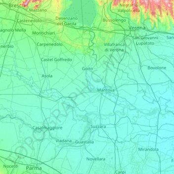
Name: Mantua topographic map, elevation, terrain.
Location: Mantua, Lombardy, Italy (44.91027 10.30906 45.42832 11.42765)
Average elevation: 60 m
Minimum elevation: 6 m
Maximum elevation: 875 m
Thank you for supporting this site ❤️
Make a donation
Make a donation
Other topographic maps
Click on a map to view its topography, its elevation and its terrain.
Thank you for supporting this site ❤️
Make a donation
Make a donation
Thank you for supporting this site ❤️
Make a donation
Make a donation