
Thank you for supporting this site ❤️
Make a donation
Make a donation
Rio Conchos topographic map
Click on the map to display elevation.
Thank you for supporting this site ❤️
Make a donation
Make a donation
About this map
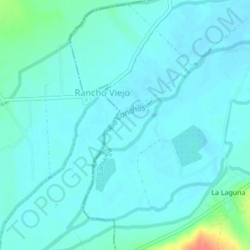
Name: Rio Conchos topographic map, elevation, terrain.
Location: Rio Conchos, Camargo, Chihuahua, 33600, México (27.62200 -105.27980 27.62768 -105.27210)
Average elevation: 1,239 m
Minimum elevation: 1,231 m
Maximum elevation: 1,285 m
Thank you for supporting this site ❤️
Make a donation
Make a donation
Other topographic maps
Click on a map to view its topography, its elevation and its terrain.