
Make a donation
Ventura County topographic map
Click on the map to display elevation.
Make a donation
Ventura County
Ventura County can be separated into two major parts, East County and West County, which are divided by the Conejo Grade. East County consists of all cities east of the Conejo Grade. Geographically East County is the end of the Santa Monica Mountains, in which the Conejo Valley is located, and where there is a considerable increase in elevation. Communities which are considered to be in the East County are Thousand Oaks, Newbury Park, Lake Sherwood, Hidden Valley, Santa Rosa Valley, part of Westlake Village, Oak Park, Moorpark, and Simi Valley. A majority of these communities are in the Conejo Valley.
Make a donation
About this map
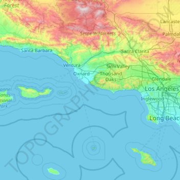
Name: Ventura County topographic map, elevation, terrain.
Average elevation: 331 m
Minimum elevation: -1 m
Maximum elevation: 2,671 m
Make a donation
Other topographic maps
Click on a map to view its topography, its elevation and its terrain.
Make a donation
Westwood
United States > California > Lassen County > Westwood
Westwood is a census-designated place (CDP) in Lassen County, California, United States. Westwood is located 20 miles (32 km) west-southwest of Susanville, at an elevation of 5,128 feet (1,563 m). Its population is 1,541 as of the 2020 census, down from 1,647 from the 2010 census..
Average elevation: 1,577 m
Prunedale
United States > California > Monterey County
Prunedale is a unincorporated community in Monterey County, California, United States. It is located 8 miles (13 km) north of Salinas at an elevation of 92 feet (28 m). The population was 18,885 as of the 2020 census, up from 17,560 in 2010. For statistical purposes, the United States Census Bureau has defined…
Average elevation: 69 m
Fort Irwin
United States > California > San Bernardino County
Fort Irwin National Training Center (Fort Irwin NTC) is a major training area for the United States military in the Mojave Desert in northern San Bernardino County, California. Fort Irwin is at an average elevation of 2,454 feet (748 m). It is located 37 miles (60 km) northeast of Barstow, in the Calico…
Average elevation: 785 m
Make a donation
Lodi
United States > California > Lodi
Lodi is flat terrain at an elevation of approximately 50 feet (15 m) above mean sea level datum. Historically the area has had some grazing land uses as well as grain production.
Average elevation: 3 m
Waterford
United States > California > Stanislaus County
The city was founded around the Tuolumne River. City population signs report Waterford's elevation is 51 feet (16 m) above sea level.
Average elevation: 49 m
Bodie
United States > California > Mono County
Bodie (/ˈboʊdiː/ BOH-dee) is a ghost town in the Bodie Hills east of the Sierra Nevada mountain range in Mono County, California, United States. It is about 75 miles (121 km) southeast of Lake Tahoe, and 12 mi (19 km) east-southeast of Bridgeport, at an elevation of 8,379 feet (2554 m). Bodie became a boom…
Average elevation: 2,627 m
Make a donation
Make a donation