
Thank you for supporting this site ❤️
Make a donation
Make a donation
Ngabang topographic map
Click on the map to display elevation.
Thank you for supporting this site ❤️
Make a donation
Make a donation
About this map
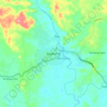
Name: Ngabang topographic map, elevation, terrain.
Location: Ngabang, Landak, West Kalimantan, 79357, Indonesia (0.34523 109.91404 0.42523 109.99404)
Average elevation: 39 m
Minimum elevation: 10 m
Maximum elevation: 120 m
Thank you for supporting this site ❤️
Make a donation
Make a donation
Other topographic maps
Click on a map to view its topography, its elevation and its terrain.
Thank you for supporting this site ❤️
Make a donation
Make a donation
Thank you for supporting this site ❤️
Make a donation
Make a donation
Thank you for supporting this site ❤️
Make a donation
Make a donation