
باری topographic map
Interactive map
Click on the map to display elevation.
About this map
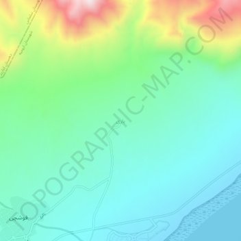
Name: باری topographic map, elevation, terrain.
Location: باری, بخش انزل, شهرستان ارومیه, Azerbaijão Ocidental, Irão (37.98899 45.03863 38.02899 45.07863)
Average elevation: 1,445 m
Minimum elevation: 1,267 m
Maximum elevation: 1,953 m
Other topographic maps
Click on a map to view its topography, its elevation and its terrain.
ایگدیر
Irão > Azerbaijão Ocidental > شهرستان ارومیه
ایگدیر, بخش مرکزی, شهرستان ارومیه, Azerbaijão Ocidental, Irão
Average elevation: 1,281 m