
Billerbeck topographic map
Interactive map
Click on the map to display elevation.
About this map
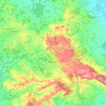
Name: Billerbeck topographic map, elevation, terrain.
Average elevation: 113 m
Minimum elevation: 67 m
Maximum elevation: 191 m
Other topographic maps
Click on a map to view its topography, its elevation and its terrain.
Havixbeck
Duitsland > Noordrijn-Westfalen > Kreis Coesfeld
Havixbeck, Kreis Coesfeld, Noordrijn-Westfalen, 48329, Duitsland
Average elevation: 96 m
Rosendahl
Duitsland > Noordrijn-Westfalen > Kreis Coesfeld > Rosendahl > Rosendahl
Rosendahl, Kreis Coesfeld, Noordrijn-Westfalen, 48720, Duitsland
Average elevation: 99 m