
Thank you for supporting this site ❤️
Make a donation
Make a donation
Vejer de la Frontera topographic map
Click on the map to display elevation.
Thank you for supporting this site ❤️
Make a donation
Make a donation
About this map
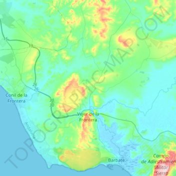
Name: Vejer de la Frontera topographic map, elevation, terrain.
Location: Vejer de la Frontera, La Janda, Cádiz, Andalusia, Spain (36.20590 -6.07971 36.37475 -5.78228)
Average elevation: 53 m
Minimum elevation: -3 m
Maximum elevation: 316 m
Thank you for supporting this site ❤️
Make a donation
Make a donation
Other topographic maps
Click on a map to view its topography, its elevation and its terrain.
Thank you for supporting this site ❤️
Make a donation
Make a donation
Conil de la Frontera
Spain > Andalusia > La Janda > Conil de la Frontera > Conil de la Frontera
Average elevation: 18 m
Thank you for supporting this site ❤️
Make a donation
Make a donation