
Thank you for supporting this site ❤️
Make a donation
Make a donation
Monte Fema topographic map
Click on the map to display elevation.
Thank you for supporting this site ❤️
Make a donation
Make a donation
About this map
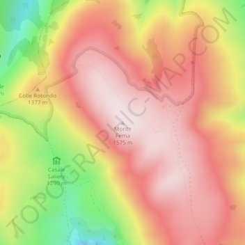
Name: Monte Fema topographic map, elevation, terrain.
Location: Monte Fema, Visso, Macerata, Marche, Italy (42.95137 13.03706 42.95147 13.03716)
Average elevation: 1,354 m
Minimum elevation: 989 m
Maximum elevation: 1,569 m
Thank you for supporting this site ❤️
Make a donation
Make a donation