
Make a donation
Hartland topographic map
Click on the map to display elevation.
Make a donation
About this map
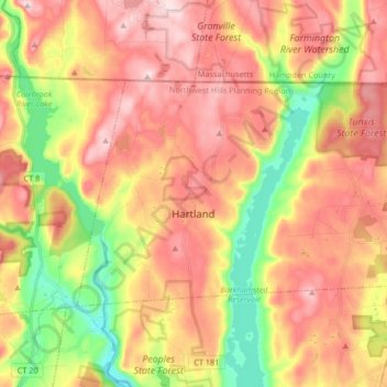
Name: Hartland topographic map, elevation, terrain.
Average elevation: 306 m
Minimum elevation: 140 m
Maximum elevation: 443 m
Make a donation
Other topographic maps
Click on a map to view its topography, its elevation and its terrain.
Winchester Center
United States > Connecticut > Northwest Hills Planning Region > Winchester
Average elevation: 385 m
The Matterhorn
United States > Connecticut > Northwest Hills Planning Region > Canaan
Average elevation: 462 m
East Hartland
United States > Connecticut > Northwest Hills Planning Region > Hartland
Average elevation: 336 m
Burrville
United States > Connecticut > Northwest Hills Planning Region > Torrington
Average elevation: 292 m
Make a donation
South Kent
United States > Connecticut > Northwest Hills Planning Region > Kent
Average elevation: 189 m
Thomaston Rod & Gun Club
United States > Connecticut > Northwest Hills Planning Region > Litchfield
Average elevation: 279 m
Sharon Avenue Park
United States > Connecticut > Northwest Hills Planning Region > Torrington
Average elevation: 229 m
Browns Corner
United States > Connecticut > Northwest Hills Planning Region > New Hartford
Average elevation: 212 m
Make a donation
Tyler Lake Heights
United States > Connecticut > Northwest Hills Planning Region > Goshen
Average elevation: 404 m
West Goshen
United States > Connecticut > Northwest Hills Planning Region > Goshen
Average elevation: 387 m