
Jahodná topographic map
Interactive map
Click on the map to display elevation.
About this map
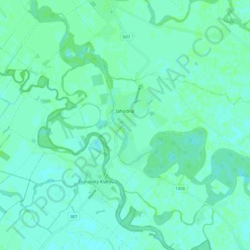
Name: Jahodná topographic map, elevation, terrain.
Average elevation: 114 m
Minimum elevation: 111 m
Maximum elevation: 117 m
The municipality lies at an altitude of 110 metres (360 ft) and covers an area of 15.691 km². The bigger part of the village lies on the left bank of the small-Danube, but there is also neighborhood on the right bank. The outer rural area on the right bank of the river comprises the following parts: Zsivaj, Huszamér, Kotrási-földek, Akói-gyep, Biffar-kertek, Albert, Völgy-zátony. The left bank rural area is composed of Jártvány, Kertalja, Duna-kert, Arany-ülő, Banga-szer, Öreg-földek, Süveges, Értő, Újmajor, Szügyi-hajlás.
Other topographic maps
Click on a map to view its topography, its elevation and its terrain.
Orechová Potôň
Slovakia > Region of Trnava > District of Dunajská Streda
Orechová Potôň, District of Dunajská Streda, Region of Trnava, Western Slovakia, 930 02, Slovakia
Average elevation: 118 m
Trhová Hradská
Slovakia > Region of Trnava > District of Dunajská Streda
Trhová Hradská, District of Dunajská Streda, Region of Trnava, Western Slovakia, Slovakia
Average elevation: 113 m
Gabčíkovo
Slovakia > Region of Trnava > District of Dunajská Streda
Gabčíkovo, District of Dunajská Streda, Region of Trnava, Western Slovakia, 930 05, Slovakia
Average elevation: 114 m
Dunajská Streda
Slovakia > Region of Trnava > District of Dunajská Streda
Dunajská Streda, District of Dunajská Streda, Region of Trnava, Western Slovakia, 929 01, Slovakia
Average elevation: 115 m