
Thank you for supporting this site ❤️
Make a donation
Make a donation
Prijepolje topographic map
Click on the map to display elevation.
Thank you for supporting this site ❤️
Make a donation
Make a donation
Prijepolje
The municipality of Prijepolje covers an area of 824 km2 (318 sq mi) with an altitude ranging from 440–1,735 metres (1,444–5,692 ft). Not including the town of Prijepolje itself, it contains 96 other settlements. Those settlements are as follows, with population figures according to the 2002 census.
Thank you for supporting this site ❤️
Make a donation
Make a donation
About this map
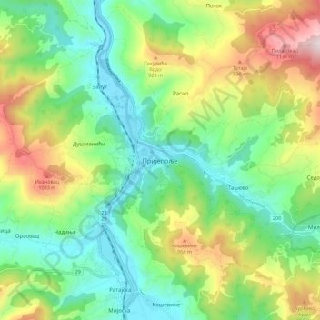
Name: Prijepolje topographic map, elevation, terrain.
Average elevation: 701 m
Minimum elevation: 435 m
Maximum elevation: 1,215 m
Thank you for supporting this site ❤️
Make a donation
Make a donation