
Make a donation
Chasnans topographic map
Click on the map to display elevation.
Make a donation
About this map
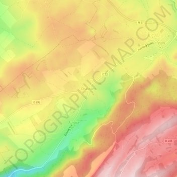
Name: Chasnans topographic map, elevation, terrain.
Average elevation: 735 m
Minimum elevation: 552 m
Maximum elevation: 856 m
Make a donation
Other topographic maps
Click on a map to view its topography, its elevation and its terrain.
Nods
France > Bourgogne-Franche-Comté > Doubs > Les Premiers Sapins
Nods est un village de l'est de la France, situé sur le plateau de Vercel, à 720 mètres d'altitude. On y accède par la RN 57 entre Besançon et Pontarlier.
Average elevation: 778 m
Rantechaux
France > Bourgogne-Franche-Comté > Doubs > Les Premiers Sapins
Rantechaux se trouve à 5 km au sud-est de Valdahon et environ 30 km au sud-est de la ville de Besançon, à vol d'oiseau. Le village qui a une altitude moyenne de 740 m se situe sur le premier plateau du département du Doubs dans le massif jurassien, à l'est de la haute vallée de la Loue (secteur Ornans -…
Average elevation: 770 m
Make a donation
Nods
France > Bourgogne-Franche-Comté > Doubs > Les Premiers Sapins
Nods est un village de l'est de la France, situé sur le plateau de Vercel, à 720 mètres d'altitude. On y accède par la RN 57 entre Besançon et Pontarlier.
Average elevation: 778 m