
Make a donation
Sibuco topographic map
Click on the map to display elevation.
Make a donation
About this map
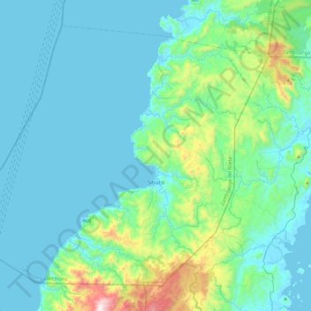
Name: Sibuco topographic map, elevation, terrain.
Average elevation: 177 m
Minimum elevation: -2 m
Maximum elevation: 1,233 m
Make a donation
Other topographic maps
Click on a map to view its topography, its elevation and its terrain.
Sindangan
Philippines > Zamboanga del Norte
Since its elevation to a municipality in 1936, people from Luzon and the Visayas continued migrating to Sindangan to settle together with their families and built businesses. That is why aside from the Subanens, there are Sindanganons whose origins are from Bohol, Cebu, Samar, Leyte, Negros, Bicol, Pampanga,…
Average elevation: 30 m
Make a donation
Make a donation
Make a donation
Make a donation
Make a donation
Make a donation
Make a donation
Make a donation
Make a donation
Make a donation
Make a donation
Make a donation
Sindangan
Philippines > Zamboanga del Norte
It was also in this same year that the province of Zamboanga was incorporated and the said towns were later transferred to the newly created province out from their mother province of Misamis. However, despite the elevation of Sindangan’s status as a municipal district, it remained unconnected by road to…
Average elevation: 30 m
Make a donation
Make a donation
Make a donation
Make a donation
Make a donation
Sindangan
Philippines > Zamboanga del Norte
Since its elevation to a municipality in 1936, people from Luzon and the Visayas continued migrating to Sindangan to settle together with their families and built businesses. That is why aside from the Subanens, there are Sindanganons whose origins are from Bohol, Cebu, Samar, Leyte, Negros, Bicol, Pampanga,…
Average elevation: 30 m
Make a donation