
Chopinot topographic map
Interactive map
Click on the map to display elevation.
About this map
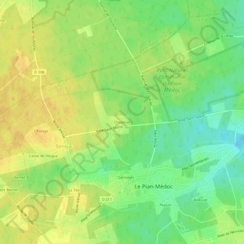
Name: Chopinot topographic map, elevation, terrain.
Average elevation: 25 m
Minimum elevation: 9 m
Maximum elevation: 37 m
Other topographic maps
Click on a map to view its topography, its elevation and its terrain.
Casse de l'Aygue
France > Nouvelle-Aquitaine > Gironde > Le Pian-Médoc > Sénéjac
Casse de l'Aygue, Sénéjac, Le Pian-Médoc, Bordeaux, Gironde, Nouvelle-Aquitaine, France métropolitaine, 33290, France
Average elevation: 30 m