
Thank you for supporting this site ❤️
Make a donation
Make a donation
Le Barthelemy topographic map
Click on the map to display elevation.
Thank you for supporting this site ❤️
Make a donation
Make a donation
About this map
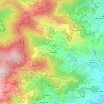
Name: Le Barthelemy topographic map, elevation, terrain.
Average elevation: 585 m
Minimum elevation: 332 m
Maximum elevation: 880 m
Thank you for supporting this site ❤️
Make a donation
Make a donation
Other topographic maps
Click on a map to view its topography, its elevation and its terrain.
Vaugneray
France > Auvergne-Rhône-Alpes > Rhône > Vaugneray
Enfin, on notera utilement les références topographique à la commune dans le fichier topographique de Marguerite Gonon.
Average elevation: 448 m