
Schney topographic map
Interactive map
Click on the map to display elevation.
About this map
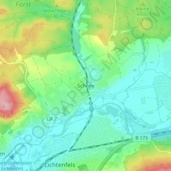
Name: Schney topographic map, elevation, terrain.
Average elevation: 295 m
Minimum elevation: 253 m
Maximum elevation: 399 m
Bohnberg | Buch am Forst | Burgberg | Degendorf | Eichig | Friesenhof | Gnellenroth | Hammer | Heinach | Isling | Karolinenhöhe | Klosterlangheim | Kösten | Köttel | Krappenroth | Lahm | Mistelfeld | Mönchkröttendorf | Nassanger | Oberlangheim | Oberwallenstadt | Reundorf | Roth | Rothmannsthal | Schney | Schönsreuth | Seehof | Seubelsdorf | Stetten | Stöcken | Tiefenroth | Trieb | Unterwallenstadt | Weingarten
Other topographic maps
Click on a map to view its topography, its elevation and its terrain.
Roth
Deutschland > Bayern > Landkreis Lichtenfels > Lichtenfels > Roth
Roth, Lichtenfels, Landkreis Lichtenfels, Bayern, 96272, Deutschland
Average elevation: 381 m
Reundorf
Deutschland > Bayern > Landkreis Lichtenfels > Lichtenfels > Reundorf
Reundorf, Lichtenfels, Landkreis Lichtenfels, Bayern, 96231, Deutschland
Average elevation: 288 m
Oberlangheim
Deutschland > Bayern > Landkreis Lichtenfels > Lichtenfels
Oberlangheim, Lichtenfels, Landkreis Lichtenfels, Bayern, 96215, Deutschland
Average elevation: 409 m
Mistelfeld
Deutschland > Bayern > Landkreis Lichtenfels > Lichtenfels
Mistelfeld, Lichtenfels, Landkreis Lichtenfels, Bayern, 96215, Deutschland
Average elevation: 362 m
Klosterlangheim
Deutschland > Bayern > Landkreis Lichtenfels > Lichtenfels
Klosterlangheim, Lichtenfels, Landkreis Lichtenfels, Bayern, 96215, Deutschland
Average elevation: 370 m