
Thank you for supporting this site ❤️
Make a donation
Make a donation
San Javier topographic map
Click on the map to display elevation.
Thank you for supporting this site ❤️
Make a donation
Make a donation
About this map
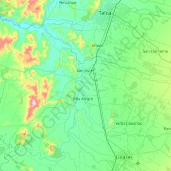
Name: San Javier topographic map, elevation, terrain.
Location: San Javier, Provincia de Linares, Maule Region, Chile (-35.85708 -72.18819 -35.41771 -71.57929)
Average elevation: 164 m
Minimum elevation: 23 m
Maximum elevation: 877 m
Thank you for supporting this site ❤️
Make a donation
Make a donation
Other topographic maps
Click on a map to view its topography, its elevation and its terrain.
Los Cristales
Chile > Maule Region > Provincia de Linares > Longaví > Los Cristales
Average elevation: 160 m