
Essex County topographic map
Interactive map
Click on the map to display elevation.
About this map
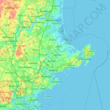
Name: Essex County topographic map, elevation, terrain.
Location: Essex County, Massachusetts, VS (42.38429 -71.25617 42.88671 -70.49901)
Average elevation: 18 m
Minimum elevation: -5 m
Maximum elevation: 143 m
Other topographic maps
Click on a map to view its topography, its elevation and its terrain.
Brookline
VS > Massachusetts > Brookline
Brookline, Norfolk County, Massachusetts, VS
Average elevation: 35 m
Oxford Heights
VS > Massachusetts > Oxford Heights
Oxford Heights, Worcester, Massachusetts, 01537, VS
Average elevation: 209 m
Mount Owen
VS > Massachusetts > Ashfield
Mount Owen, Ashfield, Franklin, Massachusetts, 01330, VS
Average elevation: 298 m