
Thank you for supporting this site ❤️
Make a donation
Make a donation
Bingenheim topographic map
Click on the map to display elevation.
Thank you for supporting this site ❤️
Make a donation
Make a donation
About this map
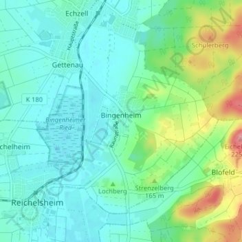
Name: Bingenheim topographic map, elevation, terrain.
Location: Bingenheim, Echzell, Wetteraukreis, Hesse, Alemania (50.35615 8.87438 50.38742 8.93831)
Average elevation: 143 m
Minimum elevation: 118 m
Maximum elevation: 223 m
Thank you for supporting this site ❤️
Make a donation
Make a donation
Other topographic maps
Click on a map to view its topography, its elevation and its terrain.