
Thank you for supporting this site ❤️
Make a donation
Make a donation
Cong topographic map
Click on the map to display elevation.
Thank you for supporting this site ❤️
Make a donation
Make a donation
About this map
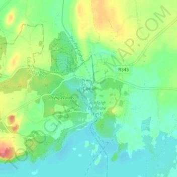
Name: Cong topographic map, elevation, terrain.
Average elevation: 23 m
Minimum elevation: 1 m
Maximum elevation: 69 m
Thank you for supporting this site ❤️
Make a donation
Make a donation
Other topographic maps
Click on a map to view its topography, its elevation and its terrain.
Killala
The Roman Catholic Diocese of Killala (Alladenis in Latin) is one of the five suffragan sees of the ecclesiastical Province of Tuam, comprising the north-western part of the County Mayo with the Barony of Tireragh in the County Sligo. In all there are 22 parishes, some of which, bordering on the Atlantic…
Average elevation: 21 m
Thank you for supporting this site ❤️
Make a donation
Make a donation
Thank you for supporting this site ❤️
Make a donation
Make a donation
Thank you for supporting this site ❤️
Make a donation
Make a donation
Thank you for supporting this site ❤️
Make a donation
Make a donation
Thank you for supporting this site ❤️
Make a donation
Make a donation
Thank you for supporting this site ❤️
Make a donation
Make a donation