
Eschdorf topographic map
Interactive map
Click on the map to display elevation.
About this map
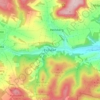
Name: Eschdorf topographic map, elevation, terrain.
Average elevation: 379 m
Minimum elevation: 257 m
Maximum elevation: 519 m
Other topographic maps
Click on a map to view its topography, its elevation and its terrain.
Roter Hügel
Deutschland > Thüringen > Landkreis Saalfeld-Rudolstadt > Rudolstadt
Roter Hügel, Pörztalsiedlung, Rudolstadt, Kamsdorf, Landkreis Saalfeld-Rudolstadt, Thüringen, 07407, Deutschland
Average elevation: 295 m
Teichröda
Deutschland > Thüringen > Landkreis Saalfeld-Rudolstadt > Rudolstadt
Teichröda, Rudolstadt, Landkreis Saalfeld-Rudolstadt, Thüringen, Deutschland
Average elevation: 333 m