
Church Road topographic map
Interactive map
Click on the map to display elevation.
About this map
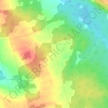
Name: Church Road topographic map, elevation, terrain.
Average elevation: 34 m
Minimum elevation: 5 m
Maximum elevation: 63 m
Other topographic maps
Click on a map to view its topography, its elevation and its terrain.
Saint Andrews
Canada > Île-du-Prince-Édouard > Kings County > Saint Andrews
Saint Andrews, Kings County, Île-du-Prince-Édouard, Canada
Average elevation: 12 m
Bristol
Canada > Île-du-Prince-Édouard
Bristol, Lot 39, Kings County, Île-du-Prince-Édouard, Canada
Average elevation: 20 m
McDonald Point
Canada > Île-du-Prince-Édouard
McDonald Point, Tranquility Road, Lot 25, Prince County, Île-du-Prince-Édouard, C1N 4H7, Canada
Average elevation: 3 m